The Met Office forecasts heatwave temperatures will climb to an extraordinary 35C on Monday and Tuesday, but cooler weather appears set to arrive shortly afterwards.
The national weather service indicates today is likely to become the hottest day of the year thus far, surpassing the record established only yesterday. Monday is anticipated to break the record once more and might even become the warmest May day on record.
With comparable peaks expected on Tuesday, the Met Office suggests temperatures will reach 30C across southern regions on Wednesday and 28C on Thursday. Nevertheless, meteorological models currently indicate the cold spell may not be far away.

The ECMWF model predicts temperatures could fail to climb significantly beyond 10C across substantial portions of the UK on June 3. Early morning temperatures might even drop to 0C in certain parts of Scotland.
Minimum potential temperature figures indicate eastern, central and southern England, alongside South Wales, could be the sole locations experiencing double-digit readings at 6am, reports the Mirror.
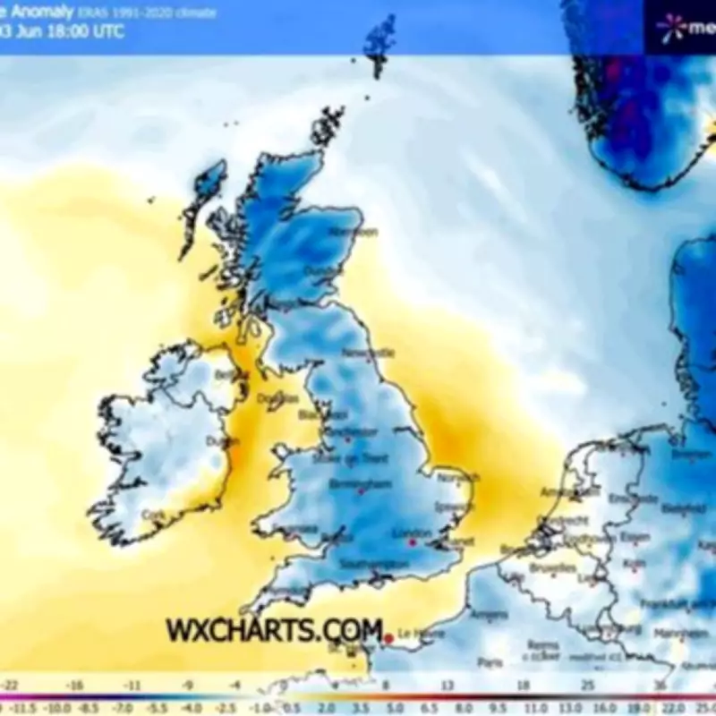
Temperature anomaly charts for early June show deep blue across much of the UK. This signifies where temperatures are forecast to fall considerably below the seasonal average.
Met Office predicts record-breaking heatwave
Meanwhile, the Met Office's 35C projections for Monday and Tuesday would represent a new benchmark for all-time May temperatures. The existing record sits at 32.8C.
Temperatures climbed beyond 28C on Friday and are forecast to continue doing so daily through to at least Thursday. This means Britain could experience a week-long heatwave.
A formal heatwave is declared when temperatures exceed the heatwave threshold for three days running. The threshold ranges from 25C to 28C depending on which UK county.
The Met Office outlook for Monday indicates: "Cloudy in northwest Scotland with rain at times, otherwise most places seeing lots of sunshine. It remains hot, especially in the south but cooler along the coasts."
For Tuesday to Thursday, it states: "Staying hot, sunny and mostly dry over the next few days with temperatures well above average. A little more patchy cloud on Thursday, perhaps with the odd shower."