The Met Office weather maps have turned orange as a hot spell approaches, with temperatures expected to reach highs of 28C by Friday. However, forecasters warn that thunderstorms could follow, particularly across parts of the East of England.
Temperature Rise and Thunderstorm Risk
Temperatures are gradually climbing this week as a zone of high pressure advances from the west. The Met Office emphasizes that while conditions will be warmer and drier, thunderstorms are probable at the week's end, especially across sections of the East of England.
On Sunday, temperatures struggled at 11.6C in the Shetland Islands and 14.8C in County Antrim, Northern Ireland, while Monday saw drizzly conditions across the South of England. Additional rainfall is anticipated on Tuesday, with the heaviest downpours likely across the Southwest of England, according to forecasters.

Friday's Warmth and Weekend Storms
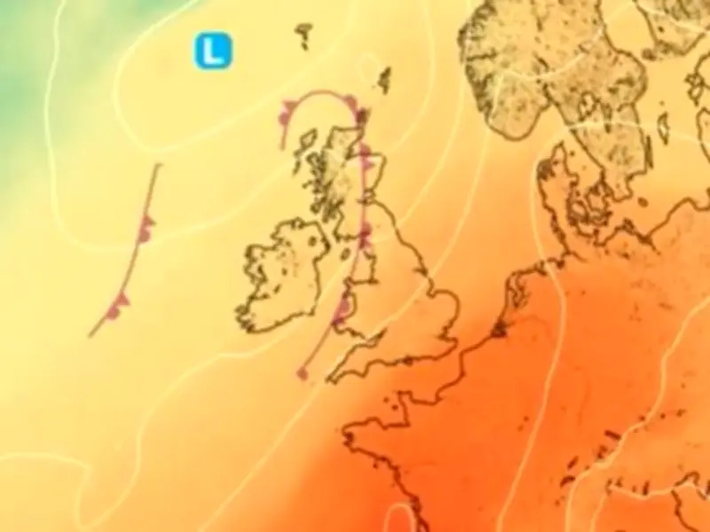
The Met Office weather chart for Friday displays an orange tone across much of the UK, indicating warmer and drier conditions. Despite the thunderstorms anticipated on Friday night and into Saturday, the East of England and the Southeast of England are expected to be the warmest locations on Friday, with 28C and 27C forecast widely across these areas.
Honor Criswick, meteorologist at the Met Office, said: "The temperatures [this week] are going to be increasing day by day, especially across the Southeast of England. This is where high pressure is starting to build this week, and we start to bring in a slightly warmer plume of air here as well. So, there's potentially some very warm if not, quite hot, weather towards the end of the week. However, this may spark off some thunderstorms."
While the Met Office has not issued any weather warnings for storms, it indicates rain will interrupt the milder spell as, during the weekend, areas of south Wales and the Southwest of England may experience showers. Even in northern England on Friday, temperatures should climb to 20C, milder than the conclusion of last week. Areas of Lincolnshire and Humberside will be amongst the warmest regions during Friday, forecasters believe.
Long-Range Outlook
Following the storms and rain across the unpredictable weekend, milder conditions are expected to resume throughout the remainder of June. The Met Office's long-range forecast, which spans June 20 to June 29, states: "There is the possibility of some very warm and humid weather across parts of south and southeast Britain at the start of this period and perhaps the chance of a few thunderstorms too. Generally more changeable to the north and west at first, but there is a signal for high pressure to build more widely as we move towards the latter part of June. This likely brings more widely drier, settled conditions with temperatures probably remaining above average for most. It is still possible that Atlantic low pressure may still bring brief spells of wet and windy weather. There is a chance that the hot conditions could return northwards accompanied by a thunderstorm risk; this all dependent on the orientation of the aforementioned high pressure."