
The United Kingdom is preparing for a significant winter onslaught, with forecasters predicting a huge blizzard could dump up to 10 inches (25cm) of snow on parts of the country next week. A severe Arctic freeze is set to grip the nation, bringing temperatures plunging to -6°C and causing widespread disruption.
Arctic Air Collides with Atlantic Systems
Following a brief milder spell after the chaos of Storm Goretti, weather maps indicate a dramatic return to icy conditions. The shift will be driven by low-pressure systems moving in from the Atlantic, which will clash with a surge of bitterly cold air moving southwards from the Arctic. This collision is expected to produce heavy and persistent snow where the moisture meets the cold front.
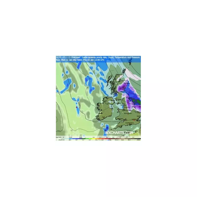
Detailed charts from WXCharts show the snowstorm developing over the UK from January 22nd, intensifying throughout the day and spreading eastwards. The most severe accumulations are anticipated for central and northern Scotland, as well as northern England.

Regional Snowfall and Temperature Forecast
The forecast suggests a stark north-south divide in conditions. Scotland could see staggering accumulations of up to 30cm (12 inches) of snow, while northern England may be hit with 14-15cm (around 6 inches). Even in the milder south of England, temperatures will struggle, hovering in low single figures during the day.
The core of the cold will be felt in Scotland, where thermometers are predicted to drop to a biting -6°C. The Met Office has highlighted the potential for 'winter hazards' in its long-range outlook for January 17-26, citing the risk of further disruptive weather.
Met Office Warns of Ongoing Unsettled Spell
In its official outlook, the Met Office states the UK will likely remain changeable, dominated by Atlantic low-pressure systems. This pattern brings showers or longer spells of rain for many, with western areas most at risk. However, the forecaster cautions that heavy rain is possible anywhere if these systems stall.
The report adds: "Periods of windy weather are also possible at times... There are also likely to be some drier, more settled periods though, mainly towards the east. Temperatures will probably be near normal overall, though the possibility exists for some colder spells in the north and east, with the potential for associated winter hazards."
Before the snow arrives, the UK is still dealing with the aftermath of Storm Goretti, facing further wet and cold weather with ongoing flooding risks this week. For instance, Birmingham is forecast to have freezing fog patches clearing on Wednesday, January 14th, leading to a cold, dry day with sunny spells before turning cloudier.
The immediate outlook for Thursday to Saturday suggests heavy rain returning later on Thursday, with possible showers on Friday before a drier Saturday.


