Snow Maps Forecast Blizzards to Cover 95% of UK in Coming Days
The Met Office has issued multiple yellow weather warnings for snow and ice, with projections indicating that a staggering 95% of the United Kingdom is set to experience snowfall in the coming days. Some regions are bracing for heavy snow, potentially leading to significant travel disruptions and hazardous conditions.
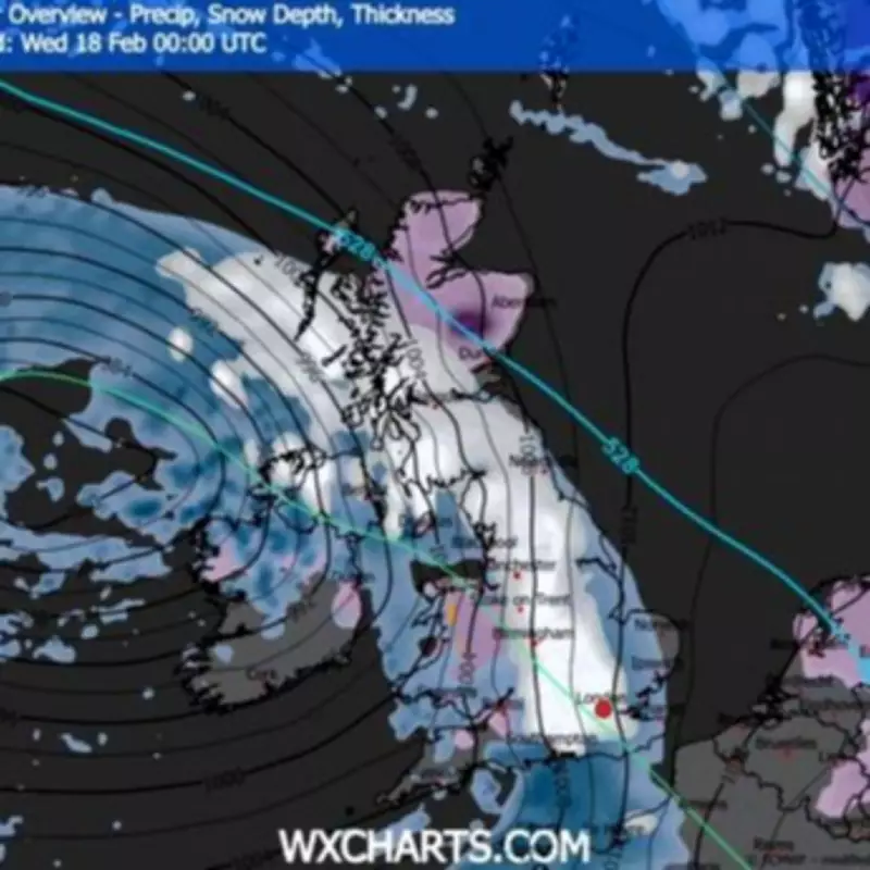
Widespread Snowfall Predicted Across the Nation
Forecaster WXCHARTS.COM projects that by midnight on Wednesday, February 18, approximately 95 per cent of the UK will be under settled snow or active snowfall. A winter overview chart from this morning reveals snowfall stretching from England's south coast all the way up to just south of the Scottish Highlands.
Nearly all of Scotland is expected to have snow lying on the ground or falling from the skies, with only limited patches along the northern and eastern coastline escaping the blanket. In Wales, northern regions may see settled snow, while the south faces heavy rainfall. Northern Ireland is depicted with roughly 1mm of snowfall hourly.

Major Urban Centers and Temperature Drops
Major urban centers including London, Birmingham, Manchester, Newcastle, Edinburgh, and Glasgow could be hit with at least 1mm of snow each hour according to the charts. The only areas not currently predicted to receive snow are isolated pockets of the southwest such as Cornwall, sections of the Northern Irish coast, and Scotland's northern edges.
A separate chart illustrating minimum temperatures points to potentially frigid conditions across the country. England may see temperatures ranging from -2 to 4C at their lowest, while Wales could experience sub-zero conditions rising to 3C.
In Scotland, the coldest temperatures are predicted to hover between 1C and plunge as low as -10 or -11C across an area spanning Perth and Kinross, Angus, and Aberdeenshire. Northern Ireland may experience marginally milder conditions of 1-4C during this period.
Active Weather Warnings and Travel Disruptions
This follows the Met Office's yellow weather warnings map, which shows nearly the entire British Isles blanketed in alerts. Three warnings took effect yesterday, comprising one for ice across Northern Ireland, another for ice spanning the entirety of southern England, and a third for snow and ice encompassing northern England, the north-east of England and northern Scotland.
A further yellow weather warning for snow and ice, covering more than 50 local authorities throughout England and Scotland, will become active at 9pm today and persist until 10am tomorrow. Areas impacted include Central, Tayside & Fife, East Midlands, Grampian, Highlands & Eilean Siar, North East England, North West England, SW Scotland, Lothian Borders, Strathclyde, West Midlands, and Yorkshire & Humber.
Those living in affected regions are cautioned that snow, at times heavy, may result in travel disruption, particularly over elevated terrain during Saturday night and Sunday morning.
Official Forecast and Public Advice
Rebekah Hicks, the Met Office's chief forecaster, stated: "Snow is likely ahead of the rain across northern England and Scotland and could reach lower levels at times Saturday night into Sunday. The snow will gradually turn to rain as the front moves east across the country on Sunday."
"The rain may be heavy at times and it will be windy in coastal areas. Additional warnings may be required. We encourage the public to keep up to date with the latest forecasts and any warnings that may be issued."
The combination of widespread snowfall, plummeting temperatures, and active weather warnings suggests that much of the UK should prepare for challenging winter conditions in the days ahead.