Met Office Snow Map Reveals Widespread Flurries Across England Tomorrow
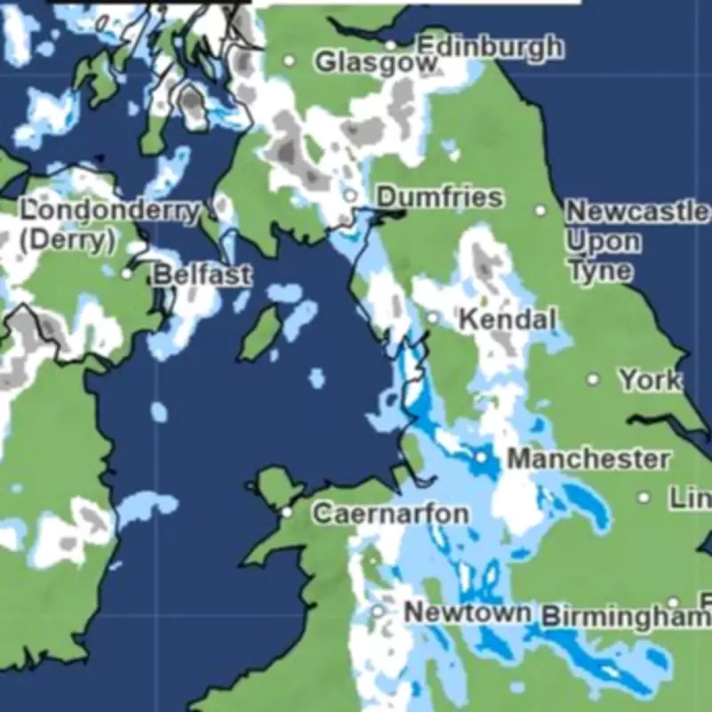
A detailed Met Office snow map has pinpointed all the regions across England, Wales, and Scotland that are expected to face flurries on Wednesday, March 25. This shift marks a significant change from last week's early taste of spring, as more unsettled and colder weather spreads rapidly across the United Kingdom.
Weather Conditions Turn Colder and Wetter
The Met Office forecasts a risk of snowfall on Wednesday, with a band of white shown spreading across the country around 7am. According to the official statement, conditions will feature sunny spells and blustery wintry showers. These showers are predicted to be most frequent across the north and northwest, where they may be heavy with hail and thunder. The overall feeling will be cold, accompanied by brisk winds that exacerbate the chill.
Outlook for the Rest of the Week
Looking ahead from Thursday to Saturday, the Met Office indicates a brief period of drier weather for most areas on Thursday. However, another spell of rain is expected to move southeastwards later in the day and into Friday. Scattered showers will follow into Saturday, remaining most frequent in the northern regions. Temperatures are projected to slowly recover as the week progresses, offering some relief from the midweek cold.

Regions Affected by the Snow Flurries
The snow map highlights numerous locations across the UK that could experience flurries. In Wales, areas such as Merthyr Tydfil, Brecon, Newtown, Knighton, Builth Wells, Hay on Wye, Bala, Welshpool, Ruthin, and Church Stretton are noted. In England, places including Telford, Stafford, Leek, Macclesfield, Rochdale, Greater Manchester, Salford, Bolton, Stockport, Wigan, Burnley, Huddersfield, Yorkshire, Sheffield, Hull, Bradford, Skipton, Penrith, Kendal, Mansfield, and Matlock are identified. Scotland is also impacted, with locations like Tartbet, Cumnock, Dumfries, Jedburgh, Fort William, Aviemore, Inverness, Glasgow, Biggar, Stranraer, Rannoch, Craig, Cairngorms, Dundee, Strathyre, Ullapool, Portree, Lairg, and Wick on the list.
Expert Commentary from the Met Office
Met Office Deputy Chief Forecaster Steven Keates provided insight into the changing weather patterns. He stated, "After a spell of mild and brighter weather, the UK will turn increasingly unsettled in the coming days. A series of weather fronts will bring periods of rain, strong winds, and much colder air by midweek. Wednesday could be quite a shock to the system." He further explained that temperatures will range from 6°C to 10°C, but it will feel closer to low single figures for many areas due to the wind. Wintry showers are likely, especially over higher ground in the north, and a widespread frost—with icy patches for some—is possible on Wednesday night. By the end of the week, conditions should become a little milder again, with many areas experiencing another spell of rain on Friday.