
The United Kingdom is preparing for a severe and disruptive winter weather event, with forecasters predicting significant snowfall that could see some regions buried under nearly two feet of snow.
Widespread Snow Accumulation Expected
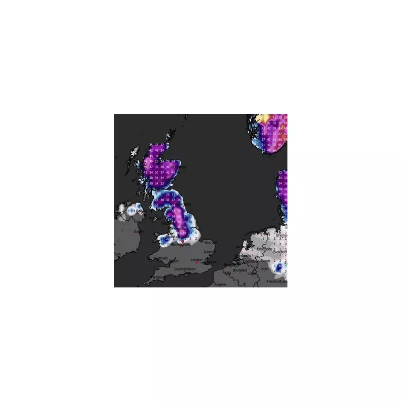
According to detailed charts from Metdesk, heavy snow is set to pile up across high ground in England. The deepest accumulations are anticipated over the Lake District, the Pennine Hills, and parts of Northern Wales. However, the most extreme totals are forecast for the Yorkshire Dales National Park, where the Arkengarthdale area of North Yorkshire could see up to 60 centimetres (more than 23 inches) of snow.
By Thursday, 15 January 2026, the wintry conditions are predicted to push much further south than initially expected, with deep snow potentially reaching as far as Birmingham. This indicates a widespread and impactful weather system moving across the country.

Official Warnings and Health Advice Issued
The Met Office has already implemented several Yellow weather warnings for snow and ice across numerous regions, including south western England, western Wales, eastern England, Scotland, and Northern Ireland. These alerts are currently in place until Tuesday, 6 January.
In its long-range forecast from 8 January to 17 January, the Met Office warns of "significant snow accumulations in places, particularly on northern hills". Scotland could receive up to 40cm of snow, accompanied by strong winds that may create dangerous blizzard conditions, leading to travel chaos, power cuts, and a potential risk to life and property.
Health authorities have also raised the alarm. Dr Agostinho Sousa, Head of Extreme Events and Health Protection at the UK Health Security Agency (UKHSA), urged the public to check on vulnerable neighbours and relatives. "The forecast temperatures can have a serious impact on the health of some people, leading to increased risk of heart attacks, strokes and chest infections, particularly for individuals over the age of 65 and those with pre-existing health conditions," he stated.
Detailed Forecast and Travel Disruption
The immediate forecast outlines a very cold and unsettled period. Sunday is expected to see snow showers continuing in coastal regions, pushing inland across northwest England and Wales by the afternoon. While other areas may stay dry and sunny, it will feel bitterly cold in the wind.
Looking ahead to the start of the following week, the cold is set to remain. The Met Office predicts: "Snow showers easing slightly on Monday, with plenty of sunshine inland. Cloudier on Tuesday with a mix of rain, sleet and snow pushing eastwards into Wednesday."
Residents across the affected regions, especially in Yorkshire, the Midlands, and Scotland, are advised to:
- Stay updated with the latest Met Office warnings.
- Avoid non-essential travel once snow begins to settle.
- Ensure they have necessary supplies and check on vulnerable friends and family.
The combination of heavy snow and strong winds promises widespread disruption to road and rail networks in the coming days.


