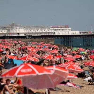
The UK heatwave has been upgraded to a 'blowtorch' weather blast, with the nation on the cusp of sweltering 30C highs. The country faces stifling conditions originating from Africa, as the mercury finally warms up following a fairly underwhelming start to May.
Sub-tropical air coming out of Africa will be swept into Britain by high pressure building through the week, according to forecasters. As the week progresses, temperatures will continue to climb into the 20s, the Met Office has said. The warmest day of the year so far was on April 8, with a high of 26.6 degrees Celsius recorded in Kew Gardens, the Met Office added.
However, we will likely exceed this on Friday, May 22, which is the date the heatwave is expected to kick off. Looking ahead to the end of the month, the BBC Weather team forecast states: 'Most probably drier and warmer than average.'

Early in the following week, high pressure might become centred further to the north-west or south-west for a couple of days, out in the eastern or north-eastern Atlantic. This may cause somewhat cooler north-west to north-easterly flows to develop for a while, with daytime temperatures close to typical for the time of year across most of the UK. However, high pressure should still exert enough influence to maintain rather dry conditions.
High pressure could soon build across the UK again, with a return to above average warmth possible as the week progresses. This should also mean a continuation of drier than normal conditions, with below average rainfall amounts in most areas across the week, and low chances of any sustained windy weather.
A similar set-up should linger into early June. Although a little rain cannot be entirely ruled out anywhere, rainfall totals should be below normal across most areas. More typical amounts for early June are possible in north-western regions, with Scotland in particular more susceptible to occasional wetter spells.
Temperatures here could remain close to or even a shade below average but across much of the UK they are most likely to be at least a little higher than the early June average. There is low confidence in the forecast for the second week of June but at the moment there is little sign of any major change to the pattern, with high pressure still extending across or near the UK.
It could weaken at times to allow an increased chance of a little rain or a few showers but rainfall amounts should not be any higher than normal in many areas, while temperatures are most likely to be near or above average. However, northern or north-western regions may have chances of turning wetter.