
The United Kingdom is preparing for another major bout of wintry weather, with fresh meteorological data indicating a significant snow event is on the horizon for the latter part of January. New weather modelling suggests a powerful blizzard could deposit as much as 66 centimetres (25 inches) of snow in some regions, with the icy conditions expected to reach as far south as Cornwall.
Snow Maps Predict Intense January Blast
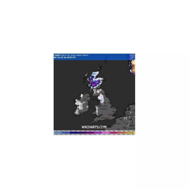
According to the latest charts from WXCharts, the country will see a return to heavy snowfall from 24 January 2026. The initial impact is forecast for Scotland, where areas around Fort William could bear the brunt of the storm. The maps indicate this region may be buried under that staggering 66cm accumulation in a single day. Concurrently, temperatures are predicted to plummet to a bitter -4°C.
This fresh warning comes as the nation continues to deal with the disruptive aftermath of Storm Goretti. The Met Office currently has a series of yellow and amber weather alerts in force for snow, ice, wind, and rain across multiple UK regions, with widespread disruption anticipated this weekend before conditions temporarily ease.

Southward Shift and Extended Outlook
The frosty grip is not expected to remain confined to the north. The forecast models show the snowy conditions shifting southwards in the days following the 24th. Locations including Manchester, Leeds, Blackpool, and even Cornwall could find themselves under a blanket of snow. Temperatures in cities like Manchester and Leeds are projected to drop to a chilly -1°C during this period.
The Met Office's extended outlook, covering 14 January to 7 February, suggests a generally changeable and unsettled pattern. Their forecast states that low-pressure systems from the Atlantic will dominate, bringing showers or longer spells of rain across much of the UK, with the heaviest precipitation likely over western high ground.
Preparing for Disruption
The forecast also warns of potential periods of strong wind or gales, particularly around coasts, especially if deep areas of low pressure develop near the UK. While some short dry spells are expected between weather systems, the overall picture is one of disruption. The Met Office indicates that a southwesterly regime is most probable, driving changeable conditions, spells of wet weather, and temperatures that will be close to the seasonal average.
Residents across the UK, from the Scottish Highlands to the southwestern tip of England, are advised to stay updated with the latest Met Office warnings and to prepare for potential travel disruption and cold weather impacts as January draws to a close.


