
The Met Office has activated a significant yellow weather warning for snow and ice, targeting specific areas of the Midlands. This alert highlights potential travel disruptions and hazardous conditions, although major urban centres like Birmingham are anticipated to remain largely unaffected.
Warning Details and Affected Areas
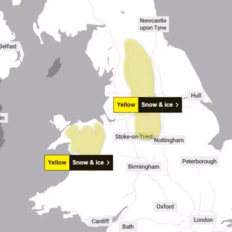
The national weather agency has confirmed that the warning is primarily focused on a northern strip of the country, extending from Cumbria down through parts of Staffordshire and Derbyshire. This includes regions within the Peak District and areas approaching Stoke-on-Trent.
The warning period is set from 6pm on Tuesday, February 3, until 9am on Wednesday, February 4. During this time, the Met Office forecasts that outbreaks of rain, sleet, and snow will move northwards across mid and north Wales, as well as northern England.

Expected Impacts and Travel Advice
Residents in the warned zones should prepare for possible disruptions, particularly to road and rail networks. The Met Office has explicitly stated that snow and ice could lead to longer journey times, with some routes experiencing delays or closures.
Additional risks include injuries from slips and falls on icy surfaces. The agency has cautioned that untreated roads, pavements, and cycle paths may develop dangerous icy patches, increasing the hazard for pedestrians and cyclists.
Snow accumulations are predicted to be most significant above 200 metres, where one to three centimetres could settle. However, the Met Office notes that a light dusting is possible at lower elevations. There is also a minor risk of transient freezing rain over higher ground, which would exacerbate ice formation.
Birmingham and Black Country Forecast
In contrast to the warned areas, Birmingham, the Black Country, and the wider West Midlands conurbation—including Solihull and Coventry—are expected to escape the most severe weather. The current forecast for Birmingham indicates light rain and breezy conditions throughout Tuesday and into early Wednesday.
The likelihood of precipitation drops to around 50 per cent by 3am on Wednesday, with any rainfall expected to cease by approximately 10am. Temperatures in the Birmingham area are projected to remain above freezing, hovering at 3 degrees Celsius or higher, significantly reducing the chance of snowfall.
By Wednesday, temperatures are forecast to rise to around 9 degrees Celsius, further diminishing any winter weather threats for the region.
Additional Warnings Across the UK
This Midlands alert is part of a broader pattern of winter weather warnings issued by the Met Office. Separate snow and ice warnings are in effect for the same period in northern and north-western Wales.
Furthermore, Scotland is under a snow warning from midnight until 3pm on Wednesday, covering areas north of Glasgow and Edinburgh, including the Highlands and the Orkney Islands.
A yellow rain warning has also been issued for the South West of England, encompassing large parts of Cornwall, Devon, Dorset, and extending into Hampshire, including Portsmouth.
Residents across all affected regions are advised to stay updated with the latest forecasts and travel information, plan journeys carefully, and take precautions against icy conditions.


